Geospatial intelligence, grounded in the landscape.
From drone-captured imagery to spatial modelling and AI-driven analytics, our services translate landscape data into decisions communities can act on.
Drone photography & live-streaming
High-resolution aerial capture and real-time broadcast for events, inspections and storytelling.
Ecosystem monitoring
Recurring spatial surveys of habitats, vegetation health and land-use change over time.
Biodiversity & restoration planning
Measuring biodiversity loss and designing data-led restoration plans that hold up in the field.
Spatial modelling & carbon accounting
Models that support carbon accounting and urban greening — balancing growth with sustainability.
Geospatial analytics + AI
Fusing GIS with AI to make environmental management transparent, actionable and decision-ready.
Promotional videos & marketing
Branded films and campaign content that turn fieldwork into compelling visual narratives.
Preventing the next Mthatha. Rebuilding after Bongweni.
In June 2025 the Mthatha and broader Eastern Cape floods killed more than 90 people and displaced thousands. Months later, demolitions at Bongweni left families without homes and infrastructure. Cape Town has faced its own cycle of devastating storm-surge flooding.
Our drone surveys, terrain models, flood-risk mapping and live-streamed situational awareness help municipalities, disaster-management teams and community organisations see floods coming earlier, plan evacuation routes, identify safe re-settlement land and document damage for rebuild funding — fast.
Death toll rises in South Africa Eastern Cape floods
Mthatha submerged as schoolchildren and families are swept away in catastrophic flooding.
Eastern Cape floods: what went wrong
Climate scientists call for better early-warning systems and spatial planning.
Cape Town storms displace hundreds
Recurring storm-surge flooding overwhelms low-lying communities across the Western Cape.
Where our work meets the ground.
Two recent events shape how we think about geospatial work in service of South African communities.
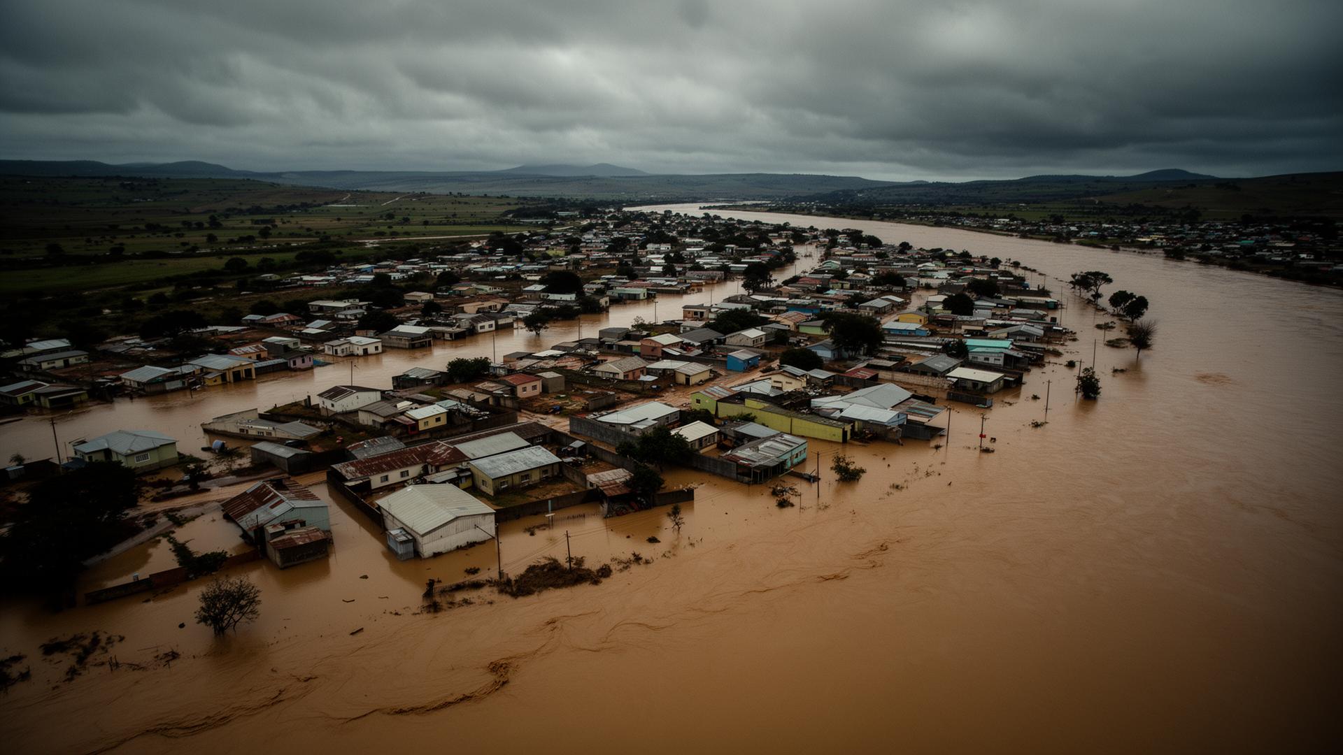
Mthatha floods — the case for geospatial early warning
How drone DTMs, flood modelling and live aerial situational awareness could change the outcome of the next event.
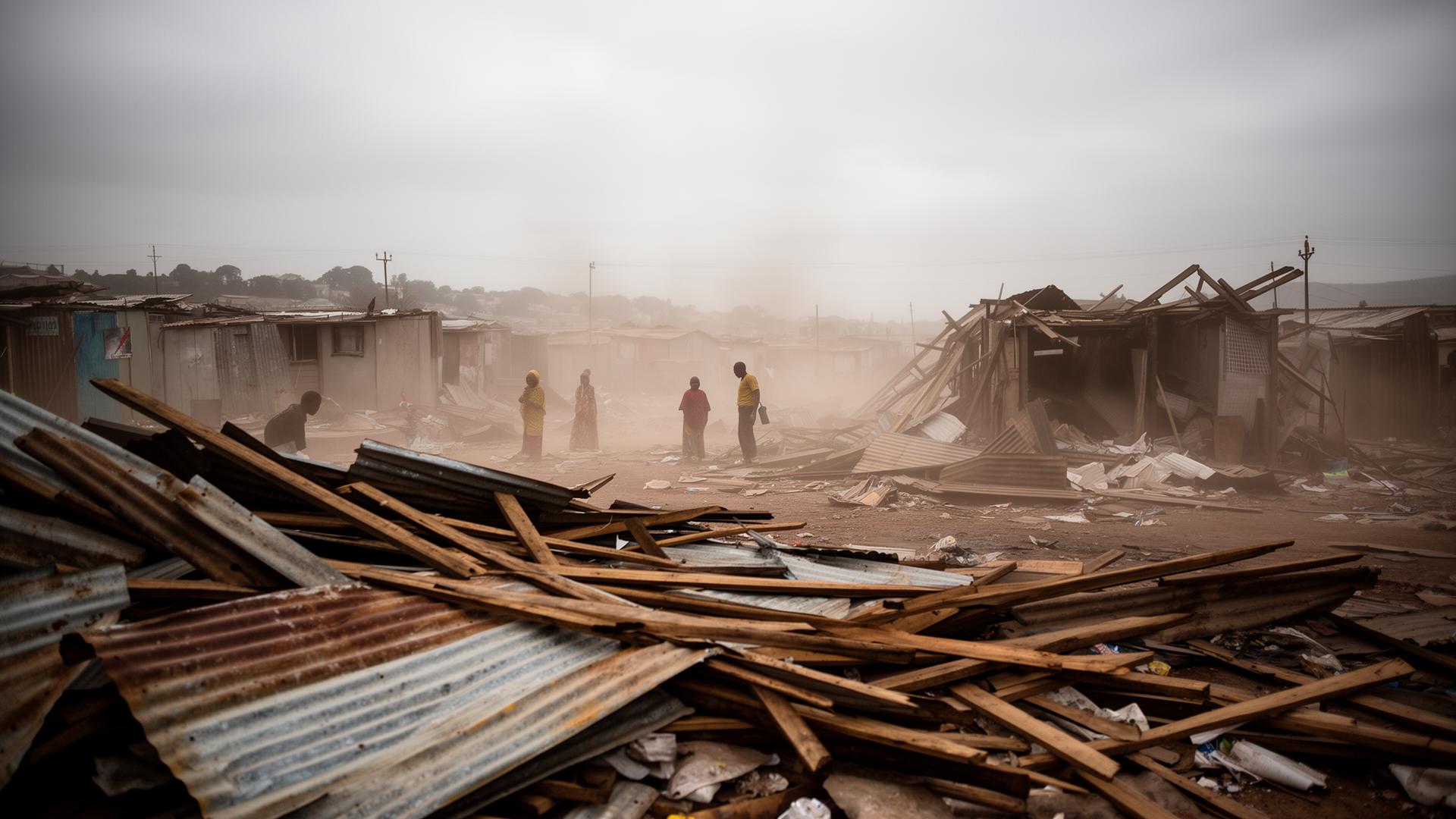
Bongweni Location — mapping what was lost
Independent, time-stamped spatial evidence in support of displaced families and a just rebuild.
Geospatial mapping, captured from above.
Reference footage. Project footage available on request.
Detailed service notes.
Climate Intelligence
Environmental and climate-related insights to support planning, risk management, and sustainable development.
We translate climate data into decision-ready intelligence — temperature trends, precipitation models, flood probability surfaces and exposure indices — so municipalities and partners can plan with confidence.
GIS & Spatial Analysis
Advanced Geographic Information Systems to analyse, visualise and interpret spatial data.
From cadastral overlays to terrain modelling and multi-criteria suitability analysis, our GIS workflows turn raw geographies into clear maps, dashboards and policy briefs.
Environmental Monitoring
Tracking environmental conditions, land use change, ecosystem health and climate impacts.
Time-series remote sensing, change detection and field validation combine to monitor wetlands, urban green cover, water bodies and degraded land at the resolution that matters.
Disaster Risk Management
Spatial intelligence for hazard identification, vulnerability assessment and disaster preparedness.
We build flood-risk surfaces, exposure registries and response-time models that help authorities anticipate, prepare for and respond to climate-driven disasters.
Sustainable Development Planning
Evidence-based planning for municipalities, organisations and communities.
Spatial development frameworks, settlement layouts and infrastructure plans grounded in data — designed with the communities who live with the outcomes.